For the people surviving the fires in Los Angeles, questions as to why they started and what to do about them are a ways off. They’re just trying to put their lives back together, with a long road ahead, and I wish them all the very best.
But those questions exist and we need to consider all factors. The one factor I’ve yet to hear talked about in the mainstream media is that which the presence of fire most suggests—water. If fire is your problem, you need water. I don’t mean water in tanks or lines, pumped in for the sake of firefighting. I mean water in the land. The land too can be a reservoir for water—in soil, aquifers, vegetation and animals. And a well-watered landscape is a fire resistant one.
It can also, in the words of late Spanish meteorologist Millan Millan, beget water. Water begets water, soil is the womb, vegetation the mid wife, he said, encapsulating years of work showing how sea breezes, vegetation and inland mountains came together to create summer rains in the otherwise dry Mediterranean climate of his homeland in southeastern Spain. The local rain cycles, which he referred to as summer storms, were key to keeping the region hydrated through the otherwise long, dry, Mediterranean summers. But as he showed, they were also quite vulnerable to land damage.
Though Millan’s work was focused on southeastern Spain, he was convinced the same rain systems exist throughout the world, particularly in southern California. In fact, when it came time to present his findings in the US, he chose to do so in San Diego, seeing in the broad region a climate dynamic eerily similar to that in southeastern Spain—a sea breeze, inland mountains and serious land degradation. After his presentation, a regional official with the U.S. Forest Service approached him and said, “If what you say is true, we’re in big trouble in 20-25 years.” The year was 1995.
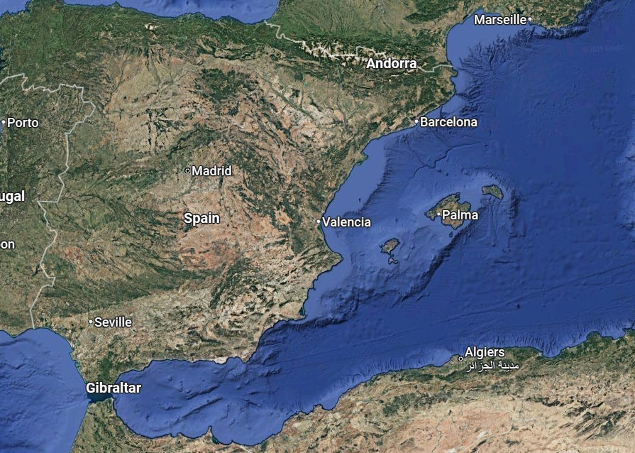
Unfortunately, Millan’s warnings and recommendations went unheeded, not only in his homeland but around the world, including southern California. If there were ever a time to bring his insights into the conversation it would be now. So let’s travel to the southeastern Spain, around Valencia and to the north and south, and take a look at what Millan discovered there, and then return to the LA basin to see how those insights apply to a part of the world now so tormented by fire.
Millan first heard the complaints of the locals in the late 1970’s, when he was conducting pollution studies in the coastal plains and hills of southeastern Spain. He’d be in the countryside setting up monitoring equipment and an old farmer would come up and say, “what you are doing is interesting, but the real problem here is it doesn’t rain as much as before.” Rivers were running dry in the summer, with wells failing and crops parched. Eventually, officials with the European Commission took notice, and in 1992 tasked Millan, by then head of the Mediterranean Center for Environmental Studies (CEAM), a large research institute, to figure out what was going on. What he figured out was that a critical source of rain, the summer storms in the mountains, were disappearing. Once-massive thunderheads were dwindling to thin wisps of unprecipitated water vapor in a rain system that had probably been around for thousands of years, but was steadily collapsing. And the cause wasn’t what was being put in the atmosphere, but was being done to the land.
Millan delineated three basic components of the summer storm regime. The first is the sea-breeze that comes in off the Mediterranean Sea. It is moist, but not moist enough to condense into clouds and rain. That additional moisture must be picked up as it travels inland over transpiring vegetation. This is the second component, the land and what grows on it. Bear in mind that this vegetation not only releases water vapor, through what is called transpiration, it also releases cloud condensation nuclei (which hereafter we’ll refer to as rain nuclei) such as terpenes and bits of biota that act as grains around which vapor can more easily condense. As this hydrated, rain nucleated air flows inland, it reaches the third component, the inland mountains, against which it rises, cools and condenses into rain, creating the summer storm. The rain that falls seeps into the ground, flowing downhill, filling aquifers and hydrating the land despite the long dry summer typical of Mediterranean climates. If it were an equation, it would be sea breeze + healthy land + rising mountain = summer rain.
Note, the first and third components, sea breeze and inland mountains. They are constants and largely physical. It’s the middle element, the soils, water table and vegetation, that varies, as it is a living system. It’s also the one where we have agency.
Let’s now take a closer look in terms of Millan’s tercet—water begets water, soil is the womb, vegetation the midwife, but starting at the end. We can easily see how vegetation can be like a midwife. Through transpiration it delivers water (as water vapor) to the air. Without midwives, only the soil could evaporate water, in miniscule amounts compared to what trees and plants accomplish through the vast surface areas of their leaves. Note how a tree branches and layers its limbs to maximize leaf or needle surface. On the top of the leaf, more sunlight can be captured—photosynthesis, which we are all well aware of. But something else is going on across the underside of the leaf—transpiration, with vast amount of moisture released, keeping both tree and surroundings cool.
The tree, of course, is also capturing carbon, some which it builds itself with. The rest it sends down to the soil. Which brings us to: soil is the womb. Womb is not a word scientists typically use, but it is the right one here. Not only does it hold water, it seems to grow it. The degree to which soil can absorb and hold water is directly related to how much life (carbon) it holds. The more carbon (life) in the soil, the more water it can hold. The more water it holds, the more life it can grow. A virtuous cycle turns, life and water increasing in tandem, not to mention filling the underground aquifers.
But there is another way the soil can beget water, that is by growing things. All living things are made partly or mostly of water, particular vegetative things, like trees, plants, bushes, lichen. An oak tree, for example, is more than half water. When soil grows life, it’s also growing water.
Of course, it works in reverse too. Take away life, you also take away water. Take away water you dry up the womb. Dry up the womb, the midwives die, and down it goes in a cycle no longer virtuous.
Dying, though, is too passive a word. Something has to kill it. That’s where human land-use comes in. Land degradation in southeastern Spain can be said to have begun in earnest when the Roman conquest began. Around 200 B.C., the Romans arrived to encounter a much wetter landscape than exists today, with extensive lowland marshes, mountain springs and oak forests. They immediately drained the coastal marshes against malaria, then began cutting down the oak and pine forests for forts, ships, temples, and iron smelters, while expanded grazing and agriculture for a growing population. Industrialization covered more ground with the spreading of concretized infrastructure, usually concentrated in the water-critical lowlands. When the Mediterranean coast became a tourist mecca, coastal marshes disappeared under hotels and parking lots. Human populations grew, along with roads and buildings and parking lots. Eventually the sea breeze arrived to encounter not the moist exhalations of oak forests and marshes, but dry air heated by human surfaces and bare land. A tipping point seems to have been reached and the rain regime is collapsing. In his final years, Millan feared the entire area was headed toward desert.
As we see, the story about rain is also a story about land and what lives on it, which means it’s also about us and how we live with, or don’t live with, the land. So let’s turn now to the LA Basin and see how the story plays out there.
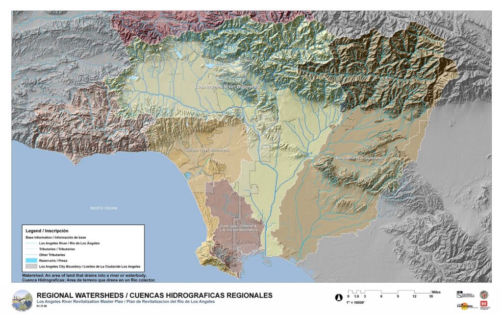
By basin I mean the broad delta of land that descends to the ocean from the San Gabriel Mountains, bordered on the north by the Santa Monica mountains and the south by the Santa Ana’s. This also describes the watersheds of LA’s two main rivers, the Los Angeles and San Gabriel, along with the Bilbao creek watershed.
Right away we see the first and third parts of Millan’s summer storm regime—ocean sea-breeze, and inland mountains to lift and cool the air mass. Note also that parts of mountain ranges dip into and enter the land in various places, even at the peninsula. This would create backstops for down-flowing water, holding it on the land to form wetlands. Finally, note the rich veining of creeks flowing into the basin. This is clearly a well-watered land. So why is it so dry? Or in Millan’s words, “Why does the land look the way it does?”
It didn’t always. As in the Mediterranean, prior to colonization it was a lusher and much wetter place. A number of tribes lived in coastal southern California, including the Chumash, Tataviam, Serrano, Kizh and the Tongva, with the Tongva, or “People of the Earth,” being the main inhabitants of the LA basin. The Tongva are believed to have arrived overland around three thousand years ago, whence they settled and flourished.
I used the word “settled.” That’s a word associated with agriculture and the Tongva didn’t practice agriculture. Rather they practiced something better described as tending. Rather than using the land to grow introduced crops, they helped the land to grow what it already grew, tending it toward what they favored. Less land use than land partnership.
A key part of this shaping and tending involved the use of fire. Researchers in a 2009 paper describe “a regional rotation system of prescribed burns to promote and exploit a diverse range of plant and animal species for food, as well as for medicines, baskets, building materials, ceremonial regalia, and so on.” Through a sophisticated weaving of small burns on 1-10 year intervals, the Tongva could produce “fine-grained vegetation patterns composed of many small stands of plants whose age structure varied from one stand to the next.” By employing such rotational cycles, they write, “Native people would have ensured that different stages of succession were continually unfolding in distinctive patches of grassland, scrubland, oak woodland, and mixed conifer forests across local regions.”
Along with fire, they tended the land through various other techniques, including “pruning, coppicing, weeding, digging, and removing debris from around plants,” as well as digging canals to bring water to favored plants and grasses, such as chia. The result was a profoundly fecund landscape, supporting not only 300,000 Tongva, but bear, antelope, elk, deer, wolf, coyote, small mammals and bird life of all kind.
It was also a wet landscape. Ecological reconstructions of the pre-colonial landscape describe a wide dispersal of lakes, river wash, wet meadows, freshwater marsh, salt marsh, salt marsh meadows, springs, streams and vernal pools. It is no wonder the Tongva consider water and life to be the same, and are reverent of both.
Add to this extensive oak groves. The Tongva created a unique acorn economy, in which acorns were a form of currency and the assiduous tending of oak trees was fundamental to life. Every village had its own oak groves, of varied kinds such as Coast Live Oak, Valley Oak, Black Oak and Canyon Live Oak. The largest and oldest trees were most prized, some growing to 500 years of age. Upon encountering the main Tongva village, Taangva, which is now downtown LA, early missionary, friar Pedro Fagas, described “great forests of oak.” It appeared to be something of a paradise.
Were there summer storms once in the mountains around this paradise? Did the land, as tended by the Tongva, produce enough moisture and rain nuclei to induce summer storms? It’s a hard question to answer. The place to start would be asking the Tongva themselves, and other tribes. Perhaps there are clues in language or ritual. But it’s clear that the conditions for such a storm system existed. The ocean was there delivering a sea breeze, and one has to assume that those breezes picked up a good bit of moisture and a wide diversity of rain nuclei as they passed over the marshes, wet meadows, flower fields and oak forests. It’s reasonable to expect that as the airmasses rose against the mountains and cooled, they condensed into rain. And what a blessing that would be in the extended dry summers of a Mediterranean climate.
At the very least, we see that the land was rich and moist and able to hold the moisture what did come in from the wet season rains and the spring mountain runoff. We also know the Tongva were able to conduct routine, controlled autumn (dry season) burns without major conflagration, which indicates well hydrated vegetation. (To get a sense of how soil/plant moisture affects a plant’s flammability, watch this.) We know that the area was able to support large human, plant and animal populations, all of which needed water. And we know it was enduring, lasting over 2,500 years. The numerous villages scattered throughout the region were so stable that four separate languages emerged between them, as different as French is to Italian. It’s hard to imagine a more successful example of human/non-human coexistence.
It came under abrupt assault however, beginning in the mid 1700’s, with the arrival of the Spanish missions. With the missionaries came diseases for which the Tongva had no immunity, decimating the population. Much of the remaining population was Christianized and enslaved to work the mission farms and cattle operations. Perhaps the first land-change was one of absence, the withdrawal of Tongva hands, of the pruning, watering, and seed casting, as fire-tended flower fields gave way to scrub.
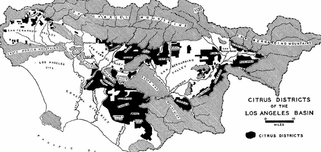
When Mexico achieved independence from Spain, they secularized the missions, but rather than granting some of the missions’ vast land-holdings to the Tongva, as was promised, they distributed the land amongst private rancheros. The Tongva found themselves landless in their own homeland, refugees in a landscape that by then was almost completely converted to agriculture and cattle grazing. At its peak in the mid-1800’s, 100,000 cattle grazed the Los Angeles River watershed alone. Fernando Valley, once a vast flower field, was type-converted in a matter of decades to invasive European grasses. It’s hard to overestimate how intensely these grasses spread. Since Spain too inhabits a Mediterranean climate, the grasses they brought were well ready for their new home. Meanwhile, the oak forests took on a different value—as building material, and were mostly liquidated. Except for a few scraps and relicts, vast stretches of landscape were extensively degraded.
Flood and drought followed. A severe flood in the early 1860’s was followed by back to back droughts which killed over a hundred thousand cattle, collapsing the cattle economy. On its heels came citrus and wheat production, and a burgeoning wine sector. American control brought the railroad in 1870, and soon the region was exporting water by the orange, bushel and wine bottle.
But this was still only the beginning of the land’s transformation. The real land-change, the kind we’re aware of now, came with urbanization.
The citrus industry gave the area a romantic appeal, and people began to arrive seeking what had become the “California lifestyle.” Between 1880 and 1930 the population swelled from 11,000 to 1.238,000. In downtown LA, the beginnings of the notorious LA traffic jams had already begun. Soon the motion picture and aeronautical industries appeared. Oil was discovered and LA became a west coast epicenter of car culture. The hard-scaping of landscape under cement and lawns was underway, and by the year 2000, 15 million people lived within 60 miles of downtown Los Angeles.
Here’s the basin today.
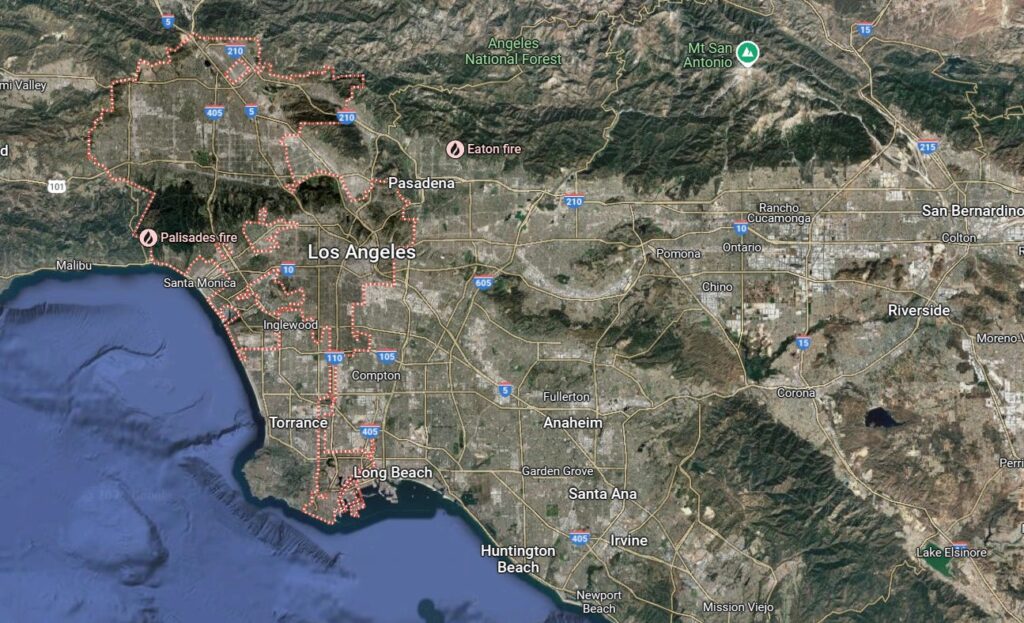
Let’s imagine again the sea-breeze coming in. Rather than being supplemented by moisture and rain nuclei rising off the marshes, flower fields, oak forest and wet meadow, it will be buffeted and desiccated by dry updrafts of air heated by sunbaked concrete. What reaches the mountains will likely be too deficient in moisture and rain nuclei to form a storm. Again, we don’t know if the basin had summer storms once or not, but we clearly see that the conditions that once favored such storms, the Tongva paradise, have been lost.
Where are the Tongva now? Although 18 treaties were signed by the US government promising land to the Tongva, the US senate never ratified them, leaving the Tongva with nothing. Even today, the federal government refuses to grant them formal tribal recognition. Yet they’ve persisted and exist formally now as separate bands organized around location and lineage. In 2022 a private citizen returned one acre of land to the Tongva Taraxat Paxaavxa Conservancy and now the Tongva finally have a place to carry out their ceremonies without having to get government permits. That acre also happens to be one of the over 14,000 acres caught in the Eaton fire.
How did the Tongva’s land (recognizing that it is all, historically, Tongva land) come through the fire? Despite the loss of two buildings and widespread burning, many of the oaks survived. Wallace Cleaves, Board President of the Tongva Taraxat Paxaavxa Conservancy, attributes traditional Tongva practices to mitigating the degree of damage. These included removal of native grasses, tending of over 50 oaks and the culling of 90 non-native and highly flammable eucalyptus trees. “We do believe that the work that we did to remove the invasive and dangerous species on the property very likely mitigated the damage, and made it much more possible for the native plants there to be able to recover and not have suffered as much,” he told the Los Angeles Times.
The work of restoration will continue, as the Tongva return native species to the land while reviving ceremonial and cultural practices. In the midst of ash and loss, a human relationship to land and water over 2,500 years old is resuming. It may be the LA basin’s most hopeful acre.