APOCALYPTIC. CATASTROPHIC. DEVASTATING. Residents of Santa Barbara and Ventura counties used these words to describe the 281,893-acre Thomas Fire that started in early December and the subsequent deadly mudslides that hit a month later. These natural disasters killed at least 22 people and destroyed more than 1,100 structures. Wildlands took a hit, too, with more than half the area burned in the Thomas Fire in either national forest or locally protected lands.
The Thomas Fire capped the deadliest and most destructive year for wildfires in California’s history. Research has shown that a warming climate has already doubled the area impacted by wildfires across the West in the past three decades, and things could get worse.
As Southern California rebuilds, will it be back to business as usual, or will a climate change-induced “new normal” help spur efforts at greater resilience?
One area of particular interest to environmentalists, county officials and researchers is the wildland-urban interface – the zone of transition between unoccupied land and human development.
The Danger Zone
Structures in the wildland-urban interface suffered immense damage during the Thomas Fire, especially in the city of Ventura, where the vast majority of buildings that burned were in that zone of transition between concrete and grass.
“For us, those interfaces [present] a significant risk to the communities,” said Sergio Vargas, deputy director of Ventura County’s Watersheds Planning and Permits Division.
Structures located in these zones of transition are especially vulnerable because they are located on the front line of oncoming flames from wildfires. Though these homes were often purchased for their easy accessibility to scenic areas, their ideal location can become a risk during wildfires and an economic burden following one.
Some insurance companies, worried about the susceptibility of homes located in high-risk fire zones, may rethink the areas in which they offer coverage following a major blaze, while some homeowners may lose their fire insurance coverage altogether, said Bob Daddi, an Ojai State Farm Insurance agent.
The proximity of homes to wilderness in the wildland-urban interface presents another significant risk: Humans, directly or indirectly, are responsible for starting 90 percent of fires in Southern California.
To deal with the threat of infernos in the future, Vargas pointed out that Ventura County will have to consider reviewing and updating county plans to incorporate “what worked and what did not work as well as expected and what type of planning policies may need to be revised or created to make the county more resilient to forest fires and fire-related risks.”
Footing the Bill
With the Thomas Fire drawing renewed concern to these vulnerable areas, the question of how to finance large-scale mitigation efforts that reduce fire risk has become a top concern. Char Miller, a professor of environmental analysis at Pomona College, proposes that Southern California counties, including Ventura and Santa Barbara, pass “fire-and-flood” control bonds that would raise revenues on a countywide level.
The money would be used to purchase two kinds of property: unbuilt sites located within areas that CalFire, the state agency responsible for fire protection, has mapped as fire hazard severity zones; and, on a willing-seller basis, residences that wildland fires have damaged or destroyed.

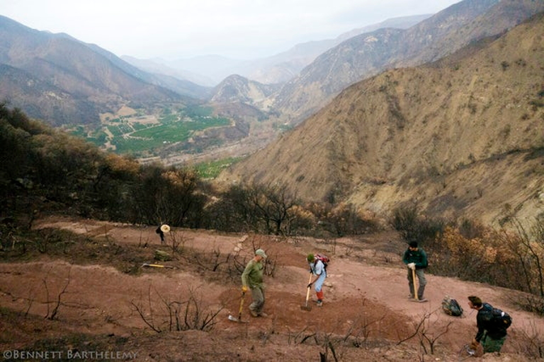
An emergency crew of trail builders in Los Padres National Forest work to shore up and build armored water bars and remove brush from fire-ravaged trails before winter rains damage them further. (©Bennett Barthelemy 2018)
A major obstacle to this approach, however, is the fact that CalFire’s maps of high-risk areas are a decade old. With climate change, Miller is concerned that these maps don’t adequately assess potential conditions 50–75 years down the road and thus are useless for helping counties identify future high-risk fire zones. CalFire did not respond for comment.
The Thomas Fire burned much of the area that was designated by CalFire as being an area of high risk, and Miller worries this could happen again.
With fire severity and frequency on the rise, Chet Work, executive director of the Land Trust for Santa Barbara County, sees the idea of “fire-and-flood” control bonds as a promising solution.
In addition to purchasing undeveloped lands, he says that these funds could be used to buy or put a conservation easement on agricultural lands that created buffers against the Thomas Fire, contingent on the landowners’ willingness. This in turn would preserve the county’s agricultural aesthetic while also protecting the built environment from flames.
During the Thomas Fire, agriculture in the wildlife-urban interface, particularly citrus and avocados, prevented the fire from burning into cities, surprising many county officials and locals.
The reason for this is simple: fuel.
“Well-watered living trees do not burn easily,” said John Krist, chief executive officer of the Farm Bureau of Ventura County. “Although many orchards were significantly charred along the edges, it was rare to see fire making its way deep into the groves.”
That is not to say, however, that Ventura County’s farms and ranches went unscathed. A preliminary damage assessment by the Ventura County agricultural commissioner found that the fire affected more than 10,289 acres of irrigated cropland and another 60,000 acres of rangeland, with damage costs reaching an estimated $171 million.
Even with intentional land protection, farms do not guarantee a safeguard against a fire propelled by 50mph Santa Ana winds, Krist cautions. The severity of the Thomas Fire has been largely attributed to a Santa Ana wind episode that lasted two to three times longer than those historically recorded. A U.S. Forest Service report also predicts, thanks to climate-driven processes, a shift in the timing of Santa Ana winds from September/October to November/December and an increase in the area burned in wind-driven fires in coming years.
The Need for Forest Restoration
Besides the agricultural land and homes lost in the Thomas Fire, protected areas, especially the Los Padres National Forest located to the north of the affected cities of Ojai and Santa Barbara, were affected. More than 152,000 acres burned in Los Padres.
While these areas naturally burn on a routine basis, uncertainty around the intensity and frequency of natural disasters in a warmer climate is a matter of concern and has prompted calls for more fire-resilient forest management.
This type of management entails using land-based interventions, such as forest thinning or changes in management practices, to create healthier and more resilient ecosystems. The specific interventions vary depending on the challenges confronting each forest.
As with managing the wildland-urban interface, the main barrier is financial. The U.S. Forest Service has a tight budget. It now spends the vast majority of the money it does have fighting yearly blazes, with little left over to prepare for warming temperatures. Los Padres composes a fraction of the 193 million acres of national forest and grasslands, approximately one-third of which are considered to be at “high risk” for severe wildfires.
One possible solution to help close the funding gap is the Forest Resilience Bond. Through this approach, private investors would provide the upfront capital necessary to restore national forests and reduce the impact of wildfires. In California alone, the cost of forest restoration to address catastrophic wildfire issues is more than $6 billion, according to a calculation by the World Resources Institute. The Forest Service does not have the funds to foot the whole bill.
Todd Gartner of the World Resources Institute explains that the Forest Resilience Bond could wield private investment. This could ensure the resources are available upfront to accomplish the restoration work that is specific to national forests throughout California in the face of tight annual budgets and challenges around federal budget cycles for multiyear projects.
The beneficiaries of the restoration work would make payments back to the investors based on the project’s success and on cost-sharing. The beneficiaries could include water utilities, electric utilities, the recreational industry and the Forest Service itself. Water districts across Santa Barbara and Ventura counties, including in Goleta and Ojai, are concerned about the future water quality of local surface supplies due to the environmental degradation caused by the Thomas Fire.
“Our ability to pay attention is time-defined,” said Pomona’s Miller. “The farther away we get from a particular episode like the Thomas Fire or the terrifying mudslides, the more likely it is that no policy in response to these twin hammers will be enacted, so the time to act is now.”
This article originally appeared on Water Deeply. You can find the original here. For important news about water issues and the American West, you can sign up to the Water Deeply email list.
Teaser photo credit: An emergency trail crew builds water bars on Cozy Dell Trail, a popular trail in the Thomas Fire burn zone in Los Padres National Forest near Ojai, California.©Bennett Barthelemy 2018
![]()


